On this page you will find:
- A member’s map of low-traffic routes in Warwick District
- WCC’s official cycleway map
- A library of member-submitted rides.
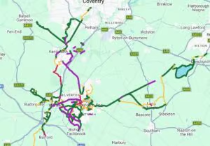
Joe’s Warwick District cycle routes
Created by cycleways member Joe Dimambro, this map highlights low-traffic routes and dedicated cycleways across Warwick District. It focuses on utility journeys, connecting shops, parks, stations, major housing areas and nearby communities.
It also shows funded projects planned for the near future, helping people see how current and upcoming routes connect into the wider network. It will be updated as changes happen.
He’s keen to expand the map with local knowledge from other members to fill in areas he’s not as familiar with. To suggest a route, please email joe.cyclingstuff@gmail.com.
Find it here: Joe’s map
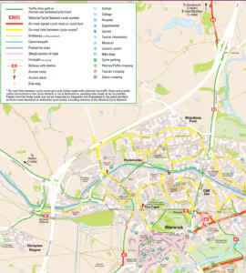
WCC’s Cycling Routes
The County Council publishes a set of cycle routes for different areas of the county. These include on and off-road routes, bridleways where cycling is permitted, canal towpaths, 20mph zones, and access ramps.
Find it here: WCC’s cycling routes
Member Rides
Cycleways would like to expand the library of member-submitted rides. Where possible, we would like suggested rides to be accompanied by a GPX file that can be downloaded to a GPS device. If you would like to submit a ride or route, please send it to: membership@cycleways.org.uk. Please supply:
- A short description
- The length of the ride
- An overview map
- Where possible, a GPX file
From Leamington
Leamington/Kineton Loop. (25 miles, with a choice of café stops)
Leamington/Long Itchington Loop (19.5 miles, with café and pub stops)